Locations: Conness Creek, Roosevelt Lake, Yosemite National Park
Dates: July 31, 2009 – August 2, 2009
Hikers: Andrew, Jared, Kevin, Matt & Nick
Photographers: Nick (unless otherwise noted as Kevin)
Went on a 3-day, 2-night backpacking and fly-fishing trip in the high country of Yosemite National Park . Included trips cross-country through Conness Creek Drainage and up to Roosevelt Lake in the shadow of Mt. Conness.
Topo map of the trip:

DAY 1:
Obligatory Half Dome shot:

The crew at the Glen Aulin trailhead. Photo: Kevin:

The hike started in Tuolumne Meadows and worked up the Glean Aulin trail towards Young Lakes:


Nick crossing Delancy Creek. Photo: Kevin:

After the crossing, we continued up the Glen Aulin trail towards Young Lakes. Photos: Kevin & Nick:


At around 9,200 feet, we headed Northwest off trail, cross-country towards the ridgeline separating the Conness Creek drainage.
Some views from the top of the ridgeline. Photos: Kevin & Nick:


Working from our high-point of the day at 9,200 ft., we headed down to around 8,350 ft. to set up base camp.
Andrew and Nick first hitting Conness Creek. We would fish this on the first and last days. Small trout, but tons of them. Photo: Kevin:

Water was cold, but HIGHLY refreshing after a big (around 9 miles) first day:

We set up camp at around 8,350 ft.:

Literally about 15 minutes after the tents were up, a nasty hail storm came in. Fortunately, we had set up a tarp to store wood under so it stayed dry. The hail was nuts – about ping pong ball sized and came down so hard there was about 2 inches of it on the ground. Looked like winter.
Fortunately, we chilled in the tents drinking some Jameson out of the Jameo Nalgene. Photo: Kevin:

Sky after the storm. Photo: Kevin:

Some B&W shots of Conness Creek by our camp where we would get water. Photos: Kevin:


Chilling by the fire. It got pretty cold at night (around 40). Good times. Photo: Kevin:

Obviously the fire got bigger. Photo: Kevin:

DAY 2:
With the base camp set, we donned the lighter packs, fly-gear and headed up on the 8 mile (round trip), 2,000 ft gain to Roosevelt Lake.
Some shots from the approach up Conness Creek, with Mt. Conness coming into view. Photos: Nick & Kevin:


The variety of terrain on this hike was awesome. Photos: Nick & Kevin:


At around 9,500 we hit this high-alpine ramp up to the rocky terrain of Roosevelt Lake and Mt. Conness. There were a ton of deer in the area, as well as some definite bear signs:


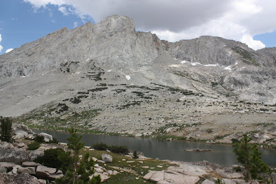
Breaking into Mt. Conness and Roosevelt Lake. Photos: Kevin:


Some scenics from Mt. Conness and the surrounding area. Photos: Kevin:


We literally got up to Roosevelt Lake, set up the fly gear and fished for about 20 minutes until another hail storm came through!


After chilling in caves, etc… for about an hour, the skies cleared, but there was some more weather approaching. Being up at 10,200 ft. was not the place to chill, especially with the temps dropping quick.
So we headed back down to base camp, and fished the creek around our camp.
Jared fishing a very active pool:


Dinner second night was TASTY. After the regular meal, it was the creation of the world’s greatest GRUL! Essentially took all the left-over ingredients from dinner both nights (burritos Day 1, pizza Day 2) and made an amazing Mexican Pizza Grul. Photo: Kevin:

Among the other ingredients: Salsa, Pepperonis, Tons of Mozz Cheese, Broken up Pita Bread, Marinera Sauce, Peppers, Onions, etc…. DELICIOUS. Photo: Kevin:

DAY 3:
We woke up, broke down camp and then fished the creek around camp. We figured, we had to at least eat 1 fish. It was TINY, but pretty good actually. Photo: Kevin:

Down the drainage to link up with the trail at Glen Aulin High Camp. Photo: Kevin:

Lower Tuolumne Falls. Photo: Kevin:

Crossing the river, back on the Glen Aulin trail. It felt good to be back on a regular trail. Photo: Kevin:

Upper Tuolumne Falls. Photo: Kevin:

Tuolumne Meadows on the last couple of miles out. Photo: Kevin:

And the trip was finished off right. Photo: Kevin:


Nice photos of a nice trip. The shot taken at 9200 feet across the ridge line is gorgeous. Including the topo map is a nice touch, but it didn’t come out very readable in my print. Makes me yearn to get back up there! Our first hike in Yosemite was Dana Peak in 1950, and the last hike in Sierra back country was over Seven Gables and into the Recesses in 1989.
Chuck